Mount Whitney: The Loftiest of the Lowliest
Now it will come about that In the last days The mountain of the house of the LORD Will be established as the chief of the mountains, And will be raised above the hills; And all the nations will stream to it.
Isaiah 2:2 NASB
The T-shirts at the ranger station in Lone Pine, CA say that if you reach the summit of Mt. Whitney, “its all downhill from there.” If you only travel in the lower 49 states, that is of course true. At 14,505 feet, Mt. Whitney is the tallest mountain in the United States south of Alaska.
It was 3:15am when we checked out of the hotel in San Jose and headed for Lone Pine. Having won the Mt. Whitney permit lottery in March, a good friend from Atlanta joined me in California in an attempt to reach the summit in winter conditions via the standard route. [1]
Using the adjective “standard” to describe the most common routes to a mountain summit can be something of a misnomer. Many associate “standard” with “normal” or “easy” rather than simply “most common.” Winter conditions on Mt. Whitney present neither normal nor easy hiking but extended uphill hikes in snow, steep climbs on exposed glaciers, and as we came to find out, at least in a few places, traverses that some might call “Everest like.” Apart from the topography issues there are also the physical challenges of sea level residents swooping in to California and attempting to climb nearly three miles into the sky with only a handful of hours to acclimate.

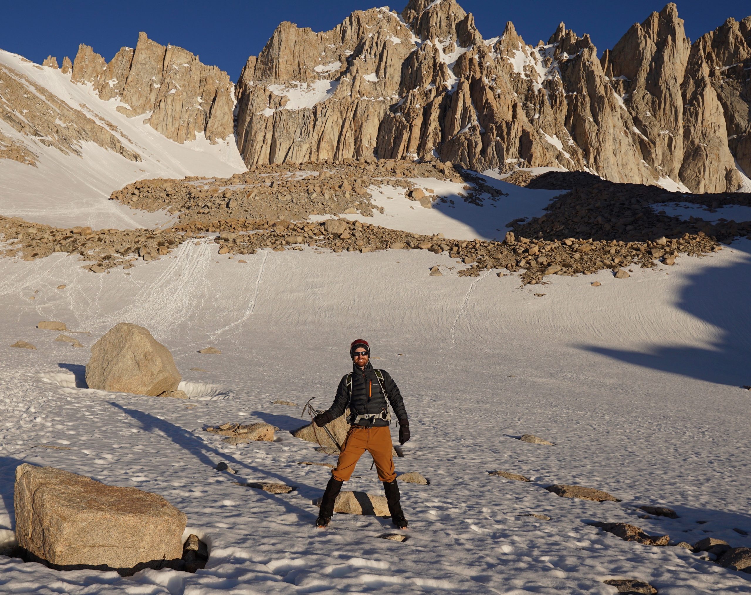
Excuses aside, we arrived at the Eastern Sierra rangers station on the south side of Lone Pine at approximately 10:00am where we picked up our single day permits (24 hour pass to climb the mountain), headed into town, and then drove up to 8,374 foot Whitney Portal Campground. History buffs will recognize Lone Pine, CA as the town used by investigators and law enforcement working to locate Charles Manson and his band of murderers before he was captured at a ranch in nearby Death Valley National Park in the early 1970s.
Whitney Portal Campground is a great spot if you like to tent or car camp and don’t have issues sleeping before the biggest climb of your life. If sleep could be an issue under the circumstances, save the camp site fee and park in the overnight hikers parking. After several fitful hours in the evening of trying to nap we finally re-checked our gear and got on the trail about 11:50pm.
We made good time on the lower portions of the trail before meeting the forested snow fields. Lone Pine Creek was interesting as we had to find our way across on rocks by our headlamps. Keep this “creek” in mind for the return trip. Highlights of this section of trail were the great views of the stars and meeting rather haggled climbers on their way down (we decided not to report them for missing their midnight permit deadline). At least one man we passed had been out unintentionally for several days and most seemed to be missing key pieces of equipment. On the bright side, they had all summited and none needed water or food.
We lost time above Outpost Camp as route finding became very difficult in the forrest, snow, and dark. While the moon moved away to give us beautiful views of the Milky Way when looking up, when looking down boot prints went every direction including one track that looked to head over a high waterfall. After some debate we decided not to go over the waterfall though we revisited this question on the way down as well.
It is no wonder the unprepared get so easily lost on “standard” routes. Imagine a heavily wooded forest on a steep slope. The small trees are buried in snow. The medium trees have a few top branches sticking out of the snow, while the large trees are prominent. The snow is not particularly fresh so pine needles, leaves, sticks, and an occasional boulder make for contrasts on the surface. Leading you in the right direction is supposed to be a trail but boot prints go in many different directions. There are no signs. Your headlamp sends shadows all around reducing trail finding visibility to a few feet. Do you go where the highest quantity of boot prints seems to lead? Do you take the route that heads uphill the most? Do you do what feels right? Tricky to say the least. Thankfully the GPS functioned well the whole hike and brought us through the trees without any issues.
If you look at a map of the “standard” route, about half way between Mirror Lake and Consultation Lake, the trail turns 180 degrees twice in order to climb a ridge to the right of Consultation Lake. We were determined to try and stay with the snow covered summer trail until The Chute at which time we would take the Chute up to Trail Crest. When we got above tree line and Mirror Lake there was an obvious boot path trail parallel to Consultation Lake but the standard route was supposed to climb the ridge. We decided to ignore the boot trail and climb the ridge. I suspect we were the only ones to make that questionable decision in a long time.

The ridge resulted in an unnerving traverse over a steep (50-60 degree +) frozen snow field just short of Trail Camp. In order to cross this we made steps into the snow field with our crampons, and used our ice axes above us (like you might see in Everest movies) to make it safely across with three points of contact. About half way across this traverse, we looked up and realized a large crevasse was above us! Not what we wanted to see but little we could do now except panic or continue across. We quickly decided on the latter and made it safely to the rocks beyond. The moral of this portion of the story is that above tree line we should have followed the boot trail and ignored the ridge trail.
The Chute is about a 1 mile glaciated slope that reaches 30 – 40 degree angles the whole way. Not terrible angles compared to Mt. Shasta and Mt. Adams but a long 1,500 – 2,000ft vertical climb nevertheless. We divided it into five phases and made good time getting to the top. We did have some excitement as the snow softened and my buddy slipped. He made a great self-arrest with his ice axe but in the process lost some water that tumbled down the mountain. We opted not to go down several thousand feet to look for it and continued up to “Trail Crest” where the real fun began.

To reach the summit of Whitney from Trail Crest, one must hike down a good bit and then work your way around the back sides of Mt. Muir and the Needles before you make it even into sight of Mt. Whitney. This 3 mile approach included the most technical climbing at altitude I have ever done. The typically narrow trail in the summer was non-existent as it was covered by slopes of snow and ice. We had to make several technical maneuvers against significant exposure to navigate the trail. Maneuvers included holding onto rocks while holding onto our ice axe and using crampons to move around corners. It involved hoping snow slopes would hold a while longer (at least while we passed) when there was no apparent way to self-arrest if we fell. It was a bit sketchy and regrettably we have no pictures due to the demands of all hands to be holding ice axes or rocks.
About 13 hours after we stepped onto the trail at Whitney Portal we summited Mount Whitney.

The views from the summit are spectacular. Hundreds of high Sierra peaks were visible and the words of Psalm 36:6 often came into mind. It is difficult at the top of a great mountain not to sit and ponder the Psalmist’s question in Psalm 8:4 and Mt. Whitney kept that question very much alive.
The summit shelter was almost completely filled with snow and we realized that the size of the summit and mountain made it a little disorienting when heading down. Heading North off the summit leads to a major cliff so with GPS we carefully navigated our way down the snow covered trail to the South.
The descent was enjoyable after we traversed the sketchy portions from the Summit to Trail Crest. We were able to glissade nearly a mile and my friend flew down well ahead of me in his first career glissade. Well done Alan! We made 2-4 miles per hour the balance of the trip and had two further surprises in store. The first was back above the waterfall. A heavily travelled boot trail through the snow led over a large waterfall. We were in route to this dangerous surprise when we corrected our route and went around the waterfall. One of the men we passed on the way up fell at the waterfall, spent several days at a dry spot near the middle of the waterfall before finding his way down with the help of his dog.

The second was Lone Pine Creek just one mile from the car on what was now a dirt trail below the snow fields. So much snow melted during the day that the ‘creek’ we easily crossed on rocks in the middle of the night was now quite the torrent of water and a strong waterfall went off the trail at a breath-taking rate and down a life-taking slope.
One of us decided to cross on submerged rocks at the edge where the danger was greatest but the water would only be slightly above the boots. The other decided the risk was too great and crossed on the uphill side by wading right through the water at its deepest but slowest rate. Neither of us knew about a secondary trail about twenty yards before the waterfall that led down to the parking lot and was used in just this very scenario.
In God’s providence we safely and successfully returned to the trailhead in about 20 hours and 14 minutes of continuous hiking. Without snow, the round trip is 22 miles and just shy of 7,000 vertical feet. In snow, it is about 18-20 miles with the same height.
If you are ever looking for a great physical adventure in God’s beautiful creation, win the Mt Whitney lottery and find your way to its lofty summit. Understand the risks, don’t climb alone, and delight in the views the Lord grants you along the way.
.
[1] The winter conditions were on the ground with significant snow accumulation. As we climbed in early June the air temperatures were only cold early in the morning at high elevation.


0 Comments